
List of Neighbouring Countries of India 2026: Map & Border Facts

India's Geographic Position at a Glance
India sits at the heart of South Asia, bordered by the Himalayas to the north and surrounded by water on three sides — the Arabian Sea to the west, the Bay of Bengal to the east, and the Indian Ocean to the south. This unique geography gives India both extensive land frontiers and a long coastline, making its neighbourhood one of the most strategically important in the world.
Understanding india neighbour countries isn't just a geography exercise — it directly feeds into India's foreign policy, defence planning, and trade relationships, which is exactly why this topic appears so consistently across UPSC, SSC, defence, banking, and state PSC exams.
What Are the Neighbouring Countries of India?
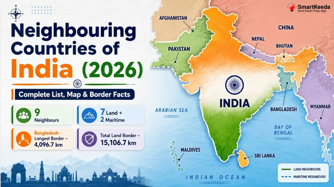
The neighbouring countries of India are the nations that share a direct land or sea boundary with it. In total, India has 9 neighbours:
Land border countries (7): Pakistan, China, Nepal, Bhutan, Bangladesh, Myanmar, Afghanistan Maritime border countries (2): Sri Lanka, Maldives
Afghanistan is a special case worth understanding rather than memorising blindly: India's claimed 106 km border with Afghanistan runs through the Pakistan-occupied Kashmir (PoK) region, which India does not actually administer. This is why some sources count India's land-bordering countries as 6 (excluding Afghanistan) and others count 7 (including it as a claimed border) — both answers can be correct depending on how the question is framed, and it's worth knowing why the discrepancy exists rather than just picking a number to memorise.
Pactice General knowledge Quizzes
Full List of Neighbouring Countries of India with Border Length
| Country | Border Type | Border Length | Capital |
| Bangladesh | Land | 4,096.7 km (longest) | Dhaka |
| China | Land | 3,488 km | Beijing |
| Pakistan | Land | 3,323 km | Islamabad |
| Nepal | Land | 1,751 km | Kathmandu |
| Myanmar | Land | 1,643 km | Naypyidaw |
| Bhutan | Land | 699 km | Thimphu |
| Afghanistan | Land (disputed, via PoK) | 106 km (shortest) | Kabul |
| Sri Lanka | Maritime | — (Palk Strait) | Sri Jayawardenepura Kotte |
| Maldives | Maritime | — (Arabian Sea) | Malé |
India's total international land border: 15,106.7 km India's total coastline: 7,516.6 km
India's Land Neighbours — Country by Country
Bangladesh
India's longest land border, running along West Bengal, Assam, Meghalaya, Tripura, and Mizoram. Relations are shaped by shared river systems, trade, and cooperation rooted in India's support during Bangladesh's 1971 Liberation War.
China
Runs along Ladakh, Himachal Pradesh, Uttarakhand, Sikkim, and Arunachal Pradesh. The relationship is governed partly by the 1954 Panchsheel Agreement, though territorial disputes remain in Aksai Chin and Arunachal Pradesh. The de facto border here is called the Line of Actual Control (LAC).
Pakistan
Borders Jammu & Kashmir, Ladakh, Punjab, Rajasthan, and Gujarat. This border traces back to the 1947 Partition, and the de facto boundary in the Kashmir region is known as the Line of Control (LoC).
Nepal
An open, largely unfenced border shared with Uttarakhand, Uttar Pradesh, Bihar, West Bengal, and Sikkim, allowing free movement of people under a longstanding bilateral treaty.
Myanmar
Borders Arunachal Pradesh, Nagaland, Manipur, and Mizoram. India's Andaman and Nicobar Islands also share a maritime boundary with Myanmar, in addition to the mainland land border.
Bhutan
A close and largely cooperative relationship along Arunachal Pradesh, Assam, Sikkim, and West Bengal, with India acting as a major development and infrastructure partner.
Afghanistan
A short, 106 km claimed border via the Pakistan-administered Gilgit-Baltistan region, making it more a matter of territorial claim than an actively managed international frontier.
India's Maritime Neighbours
Sri Lanka
Separated from India by the narrow Palk Strait and the Gulf of Mannar, with the mythological Ram Setu (Adam's Bridge) forming a chain of shoals between the two nations.
Maldives
An island nation in the Arabian Sea, southwest of India's mainland, with maritime boundaries closely tied to India's Lakshadweep islands.

Indian States That Share International Borders
| Fact | State(s) |
|---|---|
| Longest total international border | West Bengal |
| Shortest total international border | Nagaland (borders only Myanmar) |
| States/UTs bordering exactly 3 countries | Ladakh, Sikkim, West Bengal, Arunachal Pradesh |
| Border with China | Ladakh, Himachal Pradesh, Uttarakhand, Sikkim, Arunachal Pradesh |
| Border with Pakistan | Jammu & Kashmir, Ladakh, Punjab, Rajasthan, Gujarat |
| Border with Bangladesh | West Bengal, Assam, Meghalaya, Tripura, Mizoram |
| Border with Nepal | Uttarakhand, Uttar Pradesh, Bihar, West Bengal, Sikkim |
| Border with Myanmar | Arunachal Pradesh, Nagaland, Manipur, Mizoram |
| Border with Bhutan | Arunachal Pradesh, Assam, Sikkim, West Bengal |
LoC vs LAC — A Distinction Aspirants Often Mix Up
Both terms describe "unofficial" boundaries, but they apply to different neighbours and carry different legal weight:
- Line of Control (LoC): The de facto boundary between Indian- and Pakistan-administered Jammu & Kashmir, established after the 1949 Karachi Agreement. It is not a legally recognised international border.
- Line of Actual Control (LAC): The de facto boundary between India and China, broadly following the historic McMahon Line in the northeast, but without a mutually agreed, demarcated line across its full length.
A quick way to remember: LoC = Pakistan, LAC = China — mixing these up is one of the most common errors in exam answers on this topic.
List of president of India
Key Facts and Records Every Aspirant Should Know
| Distinction | Answer |
|---|---|
| Total number of neighbouring countries | 9 |
| Number of land-border neighbours | 7 |
| Number of maritime-only neighbours | 2 |
| Country with the longest land border with India | Bangladesh (4,096.7 km) |
| Country with the shortest claimed land border | Afghanistan (106 km, disputed) |
| Country with the shortest undisputed, fully administered land border | Bhutan (699 km) |
| Indian state with the longest international border | West Bengal |
| Indian state with the shortest international border | Nagaland |
| States bordering 3 different countries | Ladakh, Sikkim, West Bengal, Arunachal Pradesh |
| India's total land border length | 15,106.7 km |
| India's total coastline length | 7,516.6 km |

Prerna Mahor Success story
How Prerna Mahour Cracked SBI Clerk & IBPS Clerk Together with Private Job
20 Jul 2026

Women Freedom Fighters of India
15 Women Freedom Fighters of India: The Untold Stories of Courage (1780–1947)
18 Jul 2026

List of States and Capitals of India
List of States and Capitals of India 2026 with Union Territories
17 Jul 2026

Top 200 GK Questions in Hindi
Top 200 GK Questions in Hindi 2026: प्रतियोगी परीक्षाओं के लिए सम्पूर्ण सामान्य ज्ञान प्रश्नोत्तरी
13 Jul 2026